How hard is the Ski Haute Route? (Updated for 2021)

The Haute Route (high road) is the quintessential ‘must do’ ski tour and appears frequently on bucket lists. For every ski tourer it is a milestone and a rite of passage, but how hard is the Haute Route, and am I ready to attempt it? At Mountain Tracks, these are questions we receive a lot. Hopefully, you will find some answers here:
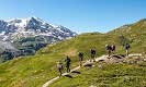
The Haute Route links two historic Alpine centres; Chamonix in France and Zermatt in Switzerland. Following an elegant and sometimes ingenious course, the route threads its way through the Mont Blanc Massif and the Swiss Valais. These two incredible ranges are among the highest areas in the Alps.
The Haute Route in its entirety dates back to 1924 (the history of the individual passes or ‘cols’ is much longer), so the journey is steeped in history and tradition. The total distance is approximately 120kms with 6,000m of ascent and descent. Described here is the Verbier route but there are many variations, some like the 'Grand Lui' or 'Classic' variations involve greater technicality.
How difficult is the Haute Route Ski Tour?
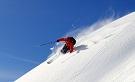
Regarding the downhill: The terrain is remote and the snow is variable so you must be an experienced and confident off-piste skier who is able to handle the changing snowpack. There are moderately steep slopes (30 degrees) and frequent changes in snow texture on the descents so it is essential that you have experience descending mixed terrain.
It is important to stress that the Haute Route is not solely for the elite and mind-bogglingly fit; it is achievable by ‘good intermediate’ off-piste skiers, with the correct preparation. Ideally your skills will have been developed over a number of years, skiing off-piste with experienced groups. Pushing yourself to finds the best snow on the mountain is the name of the game. If you are not comfortable with this, you may need more experience.
Regarding the uphill: The Haute Route is graded ‘advanced level’; this means you should be familiar and efficient using touring equipment and be able to demonstrate self-sufficiency on the mountain, for example, there are several sections where moderately steep kick turns are necessary. So at minimum, you need prior day-touring experience, but ideally you will have previously completed another hut-to-hut trip.
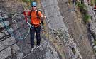
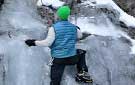
Sometime it is necessary to use crampons and ice axe, but this is usually on snow (rather than ice) and not at a high standard, so competence with mountaineering equipment is useful but not essential.
How strenuous is the route?
This is an ‘advanced level’ tour so a good level of aerobic fitness is a prerequisite. You should be able to comfortably ski all day and be happy skiing (uphill) at 400m/hr. Typically there are 3-5 hours of uphill per day and between 900m to 1300m of ascent. But don’t forget; it is normal to be tired on occasions and it is normal to try hard. Good pre-trip fitness prep is the key to success here.
Training and preparation
The trip is not just about success, it is also about enjoyment, and the fitter you can get before the trip the more fun you are going to have. In fact feeling fit in the mountains is exhilarating for its own sake and is part of the mountain lifestyle.
Our training should focus on the desired result. So in this case we would like to be able to exercise at a moderate intensity for many hours (typically 5 to 11 hours). We can achieve this by building aerobic workouts over time. The best exercises (excluding skiing!) are body-moving outdoor activities like hill walking (with a rucksack), running and cycling.
It is worth Remembering that if you are not used to exercising a lot, your body will need time to strengthen up to avoid injury.
Day by Day..
The Haute Route begins in the small town of Argentiere, near the head of the Chamonix valley. On the first day it is important that the whole group is physically prepared and has all the correct equipment. The first day begins with a warm-up but this is no substitute for a committed pre-trip training program. The daily itinerary is always subject to alteration depending on weather, mountain conditions and the ability of the group.
Day 1: Grands Montets to the Argentiere hut
In the morning, we start the tour with a warm-up at the Grands Montets ski area. Your guide will run skills sessions on avalanche search and rescue, skinning technique and use of mountaineering equipment.
The Haute Route journey officially begins at the top station of the Grands Montets (3300m) cable car! Firstly we make an exciting initial descent down the impressive Rognon glacier to the larger Argentiere glacier. Here we make our first transition to skins and make our way up the glacier to the Argentiere hut (2770m) with impressive views of the north face of Aiguille Verte, Droits and Courtes. The hut gives us our first night at altitude and helps the acclimatisation process.
Hours: 3 (plus the time spent training)
Altitude range: -800m / +200m
Guides tip: Take a great amount of care when preparing your rucksack; you don’t want to leave things behind, but the pack must stay light!
Day 2: Argentiere hut to Trient Hut
Today we pass from the French Alps to the Swiss Alps via the Col du Chardonnet; the first high altitude pass.
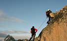
The day begins with a relatively short ski down the glacier from the hut before turning to the right and ascending (on skins) 800m to the Col du Chardonnet (3300m). This is an airy and impressive place giving incredible view both to the French and Swiss sides. The way from here involves a steep (90m) decent by rope to gain the Saleina glacier, followed by a further ascent by skins to the Saleina col. This gives access to yet another huge glacial plateaux leading to the Trient hut (3170m) where we spend the night.
Alternative route: Depending on mountain conditions, we sometimes use a different route to reach the same destination: The col de Passon and the col Superieur du Tour.
Hours: 7-8
Altitude range: -200m / +1100m
Guides tip: Stay confident and focused on the first big hill, it represents a psychological barrier.
Day 3: Trient Hut to Prafleuri hut:
Today we leave the Mont Blanc massif behind and enjoy a long descent down a remote valley which connects us with the Swiss Valais.
Initially we have an easy ski down the Trient glacier before using crampons to cross the col des Ecandies (2800m). The col gives us access to the Val d'Arpette and a superb ski descent taking us to the picturesque lakeside village of Champex.
From Champex a short journey by taxi takes us to Chable, part of the Verbier ski area. We take the skilift up as far as the Gentianes pass (2903m), and tour via a series of small cols to the summit of the Rosablanche (3336m). This summit offers a spectacular vantage point before skiing down to the Prafleuri hut (2624m).
Hours: 7-8
Altitude range: +1000m/ -1100m
Guides Tip: On this day there are lot of ‘change overs’ so practice your efficiency when taking skins on and off.
Day 4: Prafleuri hut to Dix hut
After several days on the Haute Route, we feel well acclimatised and naturally stronger. This day takes us to the Dix hut below the imposing north wall of Mont Blanc de Cheilon
From the Plafleuri we ascend to the relatively easy col des Roux. This is followed by a long traverse above Dix Lake where care is needed places. Once at the head of the lake, a long (and often hot) skin uphill takes us to the Dix Hut.
Hours: 5-6
Altitude range: +900/ -450m
Guides tip: Your clothing should be versatile, so you are neither hot nor cold at any single moment. Think carefully about how you can achieve this on the move.
Day 5: Dix hut to Vignettes hut
The voyage to the Vignettes refuge over the Pigne d’Arolla is amongst the most spectacular on the Haute route.
After a short descent onto the Dix glacier, we embark on a long ascent (1000m), passing through impressive glacial terrain to the summit of the Pigne D’Arolla, this is the highest point on the Haute Route and offers a wonderful viewpoint across the Western Alps. While ascending the ‘Pigne’ there is a delicate section called ‘pass of the Serpentine’, which often has to be climbed on foot.
From the summit, we descend for 600m to reach the Vignettes Hut, which lies on top of a huge cliff overlooking a steep glacier.
Hours: 6 to 7
Altitude range: +1000 m/ -600m
Guides tip: To get up to the Pigne d’Arolla is nearly 1000m of ascent at altitude, so ‘pace’ is critical. The guide will pace the group, but you will also need to pace yourself. Move efficiently without burning unnecessary fuel.
Day 6: Vignettes to Zermatt
The final day of the Haute Route is a magnificent journey in its own right, it is also the most strenuous day; good weather is required.
After a 5am breakfast we begin the climb up the Col de L’Eveque. After reaching the col, a good descent follows and then we embark on a second climb (first by skin, then by foot) to Col du Mont Brule. From here, the final col: the Valpelline is two hours away. At the top our efforts are rewarded by fantastic views of the Matterhorn.
Now we have the final and very long descent to Zermatt beginning on the famous Stockji and Zmutt glaciers and then leading down through traditional hamlets to Zermatt itself. The descent takes us right below the Matterhorn pyramid and is a sight to behold.
Hours: 8-12
Altitude range: +1600 / -2600m
Guides tip: Take the last day seriously. Be up early and be well organised with your kit. You will need all the skills and a good performance for the last day of the Haute Route. This day is strenuous for everyone; so harness the team spirit and focus on your goal, it’s worth it.
By Matt Dickinson IFMGA guide
Day 5: The long ascent to the summit of the Pigne d'Arolla

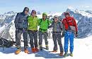
Day 3: Good weather is not guaranteed

Day 5: Descending the Pigne d'Arolla with the Otemma glacier below

Day 6: The long early morning skin to the Col de l'Évêque

Day 6: On top of the Col de la Vallpoline with the Matterhorn in the background

Day 6: Beginning the long descent of the Stockji Glacier in the direction of Zermatt

 Travel Website Development